Difference Between Plane Surveying And Geodetic Surveying
As we know that actual shape of the earth is an oblate spheroid. The length of the polar axis is shorter than the equatorial axis, but this difference is very small.
So that earth is assumed as a sphere for students understanding. Surveying thus primarily divided into two parts
- Plane Surveying
- Geodetic Surveying

Plane Surveying
Surveying, in which the surface of the earth is assumed as a plane, and the curvature of the earth is ignored, is known as plane surveying.
The most usually followed type of surveying considers the earth’s surface as a flat or “plane” surface.
It is suitable for a survey of small areas ( up to 196 Sq. Km) where the earth’s curvature does not affect the results.
In this type of survey, level lines are considered straight, and plumb-lines are considered parallel.
All the triangles formed by joining three points are considered a plane triangle, and all the angles are considered trigonometrical angles.
All the calculations are performed by using the formulas of plane geometry and trigonometry. Hence the knowledge of plane trigonometry is essential.
Typically, the error related to the calculation’s result is directly proportional to the area’s size to be surveyed.
That means, the larger the area, the higher the error margin. Plane surveys are suitable for surveying the locations and highways, cannel, landing fields, and road construction.
An arc of length 12 kilometres long resting on the surface of the earth is only 1 cm larger than the subtended chord.
For the triangle on earth’s surface holding an area of 196 square kilometres, there is only a one-second difference between the sum of the angles in a plane triangle and the sum of those in a spherical triangle.
Geodetic Surveying
It is the type of surveying in which the curvature of the earth is taken into account and a very high standard of accuracy is maintained.
Geodetic Surveying is a type of surveying which deals with large areas where it is essential to consider the earth’s actual shape and dimensions.
Its main aim is not to determine the exact earth’s shape but to establish an accurate and rigid control for all other surveys’ coordination.
This point is often ignored, and the scientific aspect is sometimes emphasized to the more practical side’s loss.
The earth’s dimensions must be known to enable the actual calculation of positions. It is also evident that it is necessary to carry out the geodetic trigonometrical survey before these dimensions can be determined.
The position is that geodetic surveys are carried out, firstly, to establish rigid coordination of all surveys, basing the computations on a previously known value of the earth’s dimensions.
Secondly, as the survey extends or is completed, further data becomes available for a check on the value used or, if necessary, to calculate another value to fit more closely the territory being surveyed.
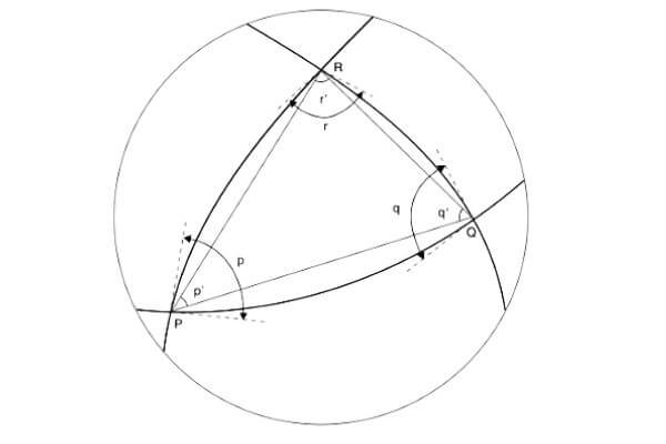
In a geodetic survey, all lines resting on the surface are curved lines and the triangles formed are referred to as Spherical triangles.
Measurements are obtained with high precision instruments, and calculations are made applying the spherical trigonometry practice.
Each geodetic station’s position is represented employing longitude and latitude, and; GPS (Global Positioning System) is usually employed for this objective.
Difference between plane surveying and geodetic surveying are as follows:
| S.No. | Plane Surveying | Geodetic Surveying |
| 1 | Curvature of earth is not taken into account. | Curvature of earth is taken into account. |
| 2 | The line joining any two points is treated as a straight line. | The line joining any two points is treated as the arc of the circle. |
| 3 | Length up to 12KM is treated as plane surveying. | Length more than 12KM is treated as geodetic surveying. |
| 4 | A triangle formed by joining three points is considered as plane triangle and angles formed are considered as trigonometry is required. | A triangle formed by joining three points is considered as spherical angles. Knowledge of spherical trigonometry is required |
| 5 | Knowledge of plane trigonometry is required. | Knowledge of spherical trigonometry is required. |
| 6 | Area up to 196 Sq. Km. is treated as a plane | Area more than 196 Sq. Km. is treated as geodetic surveying. |
| 7 | It is less accurate and less correct. | It is more accurate and more correct. |
| 8 | Used in general civil engineering survey project work | Used for the precise location of a widely distant area. |
| 9 | It employs traditional instruments like measuring tape, a chain, theodolite, etc. | It employs more accurate devices and modern technology like GPS. |
| 10 | It is done locally by individual organizations and firms. | Governments and state departments do it. |
| 11 | It is the most economical and straightforward type of surveying. | It is the most costly and complicated type of surveying. |
| 12 | It is useful for surveying in a small area. | It is useful for surveying in an extensive area. |
Thanks for reading the this article. Please don’t forget to share it.
Thanks!
Also, Read
What is Contour? – Complete Guide
Difference Between CPM and PERT