Table of Contents
What is Contour?
A contour is an imaginary line on the ground joining the point having equal elevation or a line joining the points of the same elevation is known as a contour line.
A map or plan representing a three-dimensional picture of the ground with the help of the contour line is called a contour map or plan.
What is Contour Gradient?
A line laying on the ground which maintains a constant inclination to the horizontal is known as contour gradient. It is found out by instrument clinometer.
Characteristics of the Contour Line
1. All the points on a contour line have a similar elevation.
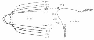
2. Two contour line never intersect each other because each contour line represents own elevation. But in case of the overhanging cliff, the contour lines cross each other.
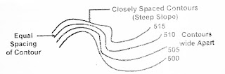
3. Spacing between contour lines indicates the nature of the ground
- Closely Spaced – Steep slope
- Wide apart – gentle or flat slope
- Equally spaced – uniform slope
4. For undulating ground or broken surface, the contours are irregular, whereas for a plane surface they are straight, parallel and uniformly spaced.
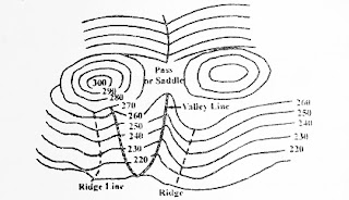
5. Contour lines, cross ridgelines (watershed lines) and valley lines at right angles. For ridgeline, the higher elevation contours are inside the loop or bend. Valley line indicated by higher elevation contours outside the loop. Valley lines indicate streams or rivers.
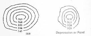
6. A series of closed contour lines with higher elevations inside the loop indicates a hill. if in such a closed loop, lower value of contour is inside, it indicates depression or pond.
7. A contour line always closes on either inside the boundary maps or outside it.
What Is Contour Interval?
It is the difference in elevation between two consecutive contour lines. For a contour map, the contour interval is always constant.
Factor affecting contour interval
Contour interval depends upon the following factor.
The Scale of The Map
Contour interval is inverse proportion to the scale of the map. If the scale is small then the contour interval should be large and vice-versa.
Nature of The Ground
The general topography of the area decides the contour interval. For a flat area, the contour interval should be small. For sloping or undulating ground the contour interval is chosen should be large.
The Purpose And The Extent of the Survey Work
If the survey work is to be used for the accurate and detailed calculations, then the small contour interval is to be chosen and a large contour interval is chosen for the following cases:
- For Catchment areas
- For reservoir
- For location survey
Time Available and Expense Admissible for the field and office work
Large contour interval is to be used if the time available for the survey work is less. The small contour interval, the survey work and plotting have to be more accurate. For small contour interval, the money required will also more as the field and office work will be more.
Consideration in making the choice of the proper contour interval
Before preparing a contour map, the contour interval required is decided. Considering the following factors on which contour interval depends
- Nature of the ground surface
- The scale of the Map
- The purpose and extent of the survey
- Time and expense required
The following contour intervals may be adopted for various purpose.
- Small scale maps or rough country – 5m to 25 m
- Large scale maps pr flat country – 0.5 m
- Location survey – 2 to 3 m
- Building sites – 0.3 to 0.5 m
- Reservoir and town planning work – 0.5 to 1 m
- Detailed design of works – 0.5 m
Methods of Contouring
There are two methods of locating contour
- Direct Method
- Indirect Method
Direct Method of Contouring
This method is tedious and time-consuming. In this method, the contours are directly located on the ground and the points of given contour are marked on the ground. These points are thereafter surveyed and their positions in the horizontal plane are found out within given boundary. Now the contour can be plotted on the map. The fieldwork involved in this method is as follows.
- Take backsight of the BM.
- Determine the height of the instrument
- Calculate the staff reading required for a particular contour by the relation.
Desired staff reading = HI – contour elevation
- Direct the staffman to move within the boundaries of the area so as to get the desired staff reading through the dumpy level.
- Mark the points on the ground by pegs or coloured tags.
- Repeat the procedure for other contours either with the same position or by shifting the instrument.
- Carry out a survey to determine relative positions of these points of a contour line in the field.
- Plot the survey to a suitable scale on the paper.
Indirect Method
In this method levelling work is carried out in the field and location of contour points is done in the office. The fieldwork involves:
- Establishing a definite pattern of ground points whose relative position are known.
- Determine the elevation of these points in the field. The indirect method is cheaper, quicker and less tedious than the direct method.
Various Indirect Methods are
- Method of Cross-section
- Method of Squares
- Technometrics Contouring
Uses of Contour Maps
- The suitable site can be selected for construction activities.
- Reservoir capacity can be determined.
- Alignment for roads, canals, transmission lines is done efficiently with the help of contour map.
- Nature of ground surface may be determined.
- Estimating the quantities of earthwork.
- The nature of ground i.e. flat, uniformly, sloping, undulating or hilly etc.
- It is possible to select the most suitable and economical sites for work such as the location of roads, railways, canals, pipelines, dams, reservoirs etc. by using contour map.
- Estimating the volume of reservoir storage water, the volume of earthwork in cutting and embankment can be done by using the contour map.
- A military operation can be planned with the help of a contour map.
- These are used for obtaining data used in the design and construction of irrigation structures such as dams.
Conclusion
This is the complete information about contour. I hope I have covered all the topics related to contour.
If you find this post helpful please don’t forget to share it.
Finally thanks! for reading the article.